
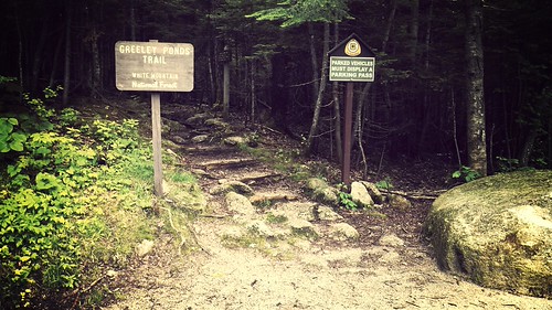
It was the perfect weather for hiking. It had rained for a few days prior, but it was going to hold out for most of the day according to the forecast. I drove the 3 hours north at 6am that morning, and arrived at the parking area for the Greely Pond Trail (which is the first 1.3 miles of the trek to the East Peak of Mount Osceola) at 9am, and walked out into the beautiful smell that the mountains in the Northeast have, that overwhelming (in a good way) smell of pine. As I got out of my car, I was the only one there, and took in the scent of the woods for a few minutes.
Of course, before I left, I made sure I left a detailed itinerary with The Wife
One thing I did not know about this trailhead from EVERY trip report I had read over the past few weeks, is that you need a pass to park there. Luckily, you can pay there, and get a day pass. I did not have the $3 on me, as I was unaware of this, but, I was able to scrounge up $3 in change from my car, and happy I did not have to drive another 30 minutes round trip to find an ATM and get change made somewhere.

I had every intention in peak bagging both Mount Osceola and the East Peak of Mount Osceola. Since I was hiking in “The Whites”, and going above 4k feet, I made sure I had rain gear, an extra top layer, along with all of my usual essentials. Made for a larger pack, but, I always like to be prepared when hiking solo.
I also knew this was a more difficult trail… but little did I know how difficult it was going to be!
The first part of the trail is 1.3 miles on the Greely Ponds trail, which meanders through the woods on a well maintained trail, over brooks and streams (most with very easy crossings), until you hit the intersection where the Mount Osceola East Peak trail starts. From there it is 1.5 miles to the summit (and another 1 mile thereafter to the Mount Osceola summit).

This trail is narrower, and already starts getting rockier and steeper – which, makes perfect sense. You are going up the side of a mountain. About halfway up the trail, it starts to get REALLY technical. There are lots of large rocks, few handholds, and it just keeps going… and going… and going… and going. I unfortunately do not have pictures of these sections, I was getting worn out and beat up quickly on my ascent, and did not bother with the camera.
I got to a place which has spectacular views, and the continuation of the trail was sketchy (did it go across the rock face? did it go up? I was uncertain…), and, I came to a realization – I was in bad *!${%#_+ shape. My legs were wobbly, my arms were aching… I decided this was a great time to have a seat, take in the view, and make a decision. The images are below are from where I hunkered down.


I sat down, had some snacks, and decided – I know the summit cannot be more than a quarter mile from here, if I do go on.. I am not going to tag both peaks, but, if I do go on… I will miss my estimated time of return. I decided to turn back. After about a 20 minute rest, I heaved my pack back on, and then retraced my route back down the trail.
I completely underestimated how beat up I was. My legs were jello. I somehow, luckily made it down, with only a few scrapes, and completely surprised I did not wear a hole through the seat of my pants – there was a lot of sliding down the faces of large rocks on my keister, as well as on my chest.
Every new rock section had its own difficulties – steepness, wetness, 45+ degree angle rocks covered with scree, little to no handholds, hidden cliffs on either side (when you see the tops of trees right next to the trail – that generally indicates a drop off!). At the top of each section I came to, had my oh s*&#! moment, sat down where I could, rested, and planned a route down it, and did it as carefully as possible.
If I had some climbing rope – I would have used that to descend several sections. This was no longer just hiking in this part of the mountain, this was mountaineering.
I did have 100’ of 550lb paracord, and carabiners, but, the thin cord would not have worked well with my hands being in the shape that they were at the time…
By the time I had reached the Greely Ponds trail, and had 1.5 miles back to the parking area, I had to literally hobble on my trekking pokes, on mostly flat ground. Every step down burned my quads with a fury that I have never felt before. I even fell a few times because my legs just gave out… on flat ground.
I am thankful I made it out, and did not get hurt, and, was not stupid and turned around when I did. If I went any further, I do not know if I would have been as lucky.
It’s been a few days now, and I still have to hobble around, my muscles are still recovering.
My plan, is on another free Friday in the next couple of weeks, is to hike from the Tripoli Road trailhead, and take the easier route, and know for a fact, that the most difficult section will be The Chimney at the col between the two peaks, with a safe alternate route if needed.
The moral of the story: Know your limits. Know when to turn around. Don’t be stupid.
In conclusion – I loved the hike, I loved the trail, and though even though I didn’t set out what I meant to do, I am still pleased about every moment of the trip, and wouldn’t have changed anything, except for maybe be in a hell of a lot better shape than I am 🙂
Below, some resources for the Osceolas, as well as some additional photos.
Resources
- Trail and Parking information @ 4000footers.com
- Trail Conditions via TrailsNH.com
- AMC Trip Planning Guide
- Weather Forecast (via Mountan-Forecast.com)
Photos
Bog crossing (lots of these along the trail)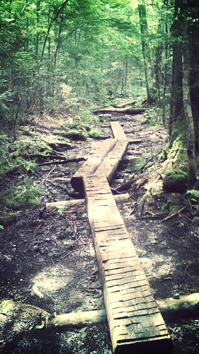
Larger water crossing

Greely Ponds Trail meandering around a large boulder
Another water crossing
Trees (there were lots of these as well along the trail)
One final note – the only reason I knew of the Osceolas and even planned to do this hike, was one of my favorite blogs to follow for trip reports in and around the White Mountains – Mountain Wandering published by Steve Smith. It turns out, I passed him and his brother right before I got back to the trailhead after my hike. What a funny coincidence!

Going back down is a real killer. I get knee ache and the old feet start playing up – they also feel super-heavy! In some was I find descents harder than ascents.
Pingback: R.I.P. Old Faithful, et. al. | Just Your Average Hiker