My muscles are just starting to recover from this weekend’s backpacking trip to the Stratton Pond Shelter via the Stratton Pond Trail in Stratton, VT. Not that it was a difficult trail, I am just woefully out of shape.
The weather was absolutely perfect for a winter snowshoe/backpacking trip. Temperatures during the day averaged in the low thirties, while overnight, temperatures dipped into the teens. We had a steady snow for just about the entire trip, and the trail was freshly broken in by our group, except for a lone set of tracks where the Stratton Pond Trail and Catamount Trail merged.
I estimate we only had to break-trail with our snowshoes about 6-8 inches down to packed snow for the most part for the trip. We had a few fresh inches on our way back out.
Once we were a couple of miles away from the trailhead, the sounds of the what seemed to be hundreds of snowmobiles that were out on the main Class 2 snowmobile trail where the trailhead was (see picture below), everything was quiet for the rest of the trip until we came back within earshot of the snowmobile trails on our trek back on Sunday. And except for what sounded like automatic rifle fire in the far distance ~7:30PM, all was blissfully quiet and serene.
I loved this trip – medium difficulty, because of snowshoeing and carrying 50lb packs. Otherwise, for a day-hike during the non-winter months, I would give this an easy rating. Below is all of the information I could furnish on the trail – I hope this is useful!
Notes About the Shelter
It is one of the nicest I have seen. It can easily sleep 12 people on the upper and lower bunks in the main part of the shelter, with an additional 4-6 comfortably in the loft area overhanging the front of the shelter. Lots of hooks to hang gear.
There is also a privy! If you need to do your business, about 100 yards away from the Shelter, there is a privy, stocked fully with mulch for covering up your business once you are done, both behind the outhouse itself, as well as extra in the shelter.

Trip Statistics
From the parking lot, not the trailhead:
Total Round-Trip Distance: 9.86 miles
Average Speed: 1.1 mph
Total Elevation Gain: 677 feet
Total Duration: 9 hours, 20 minutes Including stops, but not the overnight
Trail Maps
Trail Map with Points of Interest
USDA Forest Service Map and Information
http://www.fs.usda.gov/Internet/FSE_MEDIA/stelprdb5315046.pdf
The map in the above PDF is terrible. I would suggest printing out a trail map from here, courtesy of the USGS. Search for Stratton Pond Trail, Stratton, VT. The map above with Points of Interest, is from MyTopo.com. This is not free.
Hand-Drawn Map inside the Shelter
Inside the shelter itself, someone had posted where the platforms for camping are, trails, privy, and other points of interest around the trail. Very useful for finding your way around! (click for larger views)
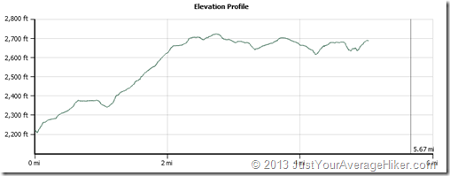
Stratton Pond Trail Elevation Profiles
From the parking lot, down Stratton-Arlington Road to the trailhead to the shelter:
And back from the Shelter to the Parking Lot:
Coordinates
Stratton Pond Shelter: 43.100521, -72.964052
Parking Lot: 43.061112, -72.967565
The address of the Trailhead is 1600 Stratton-Arlington Road, Stratton, VT. If you GPS it, it will take you down the wrong road! Use the coordinates above to get there.
Additional Information
- Photos on Flickr
- My Backpacking Gear List for this Trip (not all weights entered)
- Trip Information via Trimble Outdoors
- USDA Forest Service Information
Above: Chuck, Cotton Turtle, me, and The Machine. Photo courtesy of Bull in a China Shop. Photo taken at the intersection of the Catamount Trail and the Stratton Pond Trail.
Have any links to add regarding this trail? Leave them in the comments!


Pingback: Paint the Fence a/k/a Layering Up and Down | Just Your Average Hiker
Pingback: Changing Trekking Pole Baskets, Part Deux! | Just Your Average Hiker
Pingback: Just Your Average Review: Kelty Cosmic 0-Degree Sleeping Bag | Just Your Average Hiker
Hi JYAH,
I just found onto your site. Nice job.
My site TrailsNH is a bit of a project. I’m trying to try to pin every hiking trip report in the Northeast to a map. I just want to let you know I found and pinned your trips. I’ll be following your “Trip” tags waiting for your next hiking trip report. justyouraveragehiker.com/tag/trip/
If there is a better category or tag to follow let me know.
Kimball @ T R A I L S N H . C O M
Thank you! I’ve added a link back to your site as well under my Links section – love the site!
Pingback: Packing a Backpack | Just Your Average Hiker